Trail Walking Le Poët-Célard - poet celar - Photo
 guariso
guariso

User

© OpenStreetMap contributors
Length
Length
7.1 km
Max alt
Max alt
685 m
Uphill gradient
Uphill gradient
200 m
Km-Effort
Km-Effort  
9.8 km
Min alt
Min alt
501 m
Downhill gradient
Downhill gradient
192 m
Boucle
Boucle
Yes
Creation date :
2014-12-10 00:00:00.0
Updated on :
2014-12-10 00:00:00.0

(0 Reviews)

Walking
Walking
2h05
Difficulty : Unknown

Scan this QR Code to open this trail in the SityTrail application

FREE GPS app for hiking

Logo SityTrail SityTrail

IGN / Geographical institutes

Download SityTrail from the App Store Download SityTrail from Google Play

Logo SityTrail SityTrail World

The world is yours!

Download SityTrail from the App Store Download SityTrail from Google Play Download SityTrail on Huawei AppGallery

About

Trail Walking of 7.1 km to be discovered at Auvergne-Rhône-Alpes, Drôme, Le Poët-Célard. This trail is proposed by guariso.

Description

Balade sympa mais principalemant sur route fiche 67 de randonnee du syndicat

Elevation profile

Photos

Positioning

Country:
France
Region :
Auvergne-Rhône-Alpes
Department/Province :
Drôme
Municipality :
Le Poët-Célard
Location:
Unknown
Start:(UTM)
666933 ; 4940840 (31T) N.

Trails nearby

Trail Walking Bourdeaux - Chemin des protestants- Bourdaux - Photo
Walking
crocau

Walking

Medium
(1)
Bourdeaux, Auvergne-Rhône-Alpes, Drôme, France
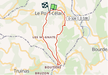
7.9 km | 11.2 km-effort
2h 48min
Yes
Trail Walking Francillon-sur-Roubion - Balade à francillon sur roubion - description et photos - Photo
Walking
bob2023

Walking

Easy
(1)
Francillon-sur-Roubion, Auvergne-Rhône-Alpes, Drôme, France
5 km | 6.7 km-effort
1h 36min
Yes
Trail Road bike Mornans - Col de Chaudiere, Saillans, Col de muse, Crupies - Photo
Road bike
GUIDE
nadd73

Road bike

Difficult
Mornans, Auvergne-Rhône-Alpes, Drôme, France
80 km | 105 km-effort
4h 27min
Yes
Trail Walking Mornans - Mornans-tour de Bezaudun - Photo
Walking
ajd26

Walking

Medium
Mornans, Auvergne-Rhône-Alpes, Drôme, France
17.9 km | 27 km-effort
4h 57min
Yes
Trail Walking Bourdeaux - 26 bourreaux huguenot 31.12.22 - Photo
Walking
GUIDE
randodyssée

Walking

Medium
Bourdeaux, Auvergne-Rhône-Alpes, Drôme, France
15 km | 23 km-effort
5h 45min
No
Trail Walking Saou - Roche Colombe depuis Saou - Photo
Walking
Noiraude

Walking

Medium
Saou, Auvergne-Rhône-Alpes, Drôme, France
11.3 km | 19.1 km-effort
7h 18min
Yes
Trail Walking Bézaudun-sur-Bîne - 2022-09-26_14h18m42_12295156 - Photo
Walking
chancha

Walking

Medium
Bézaudun-sur-Bîne, Auvergne-Rhône-Alpes, Drôme, France
6.1 km | 9.9 km-effort
2h 14min
Yes
Trail Walking Saou - un tour de Saou - Photo
Walking
andrechauvin

Walking

Medium
Saou, Auvergne-Rhône-Alpes, Drôme, France
15.2 km | 24 km-effort
6h 2min
Yes
Trail Walking Bourdeaux - col de Boutière 1 - Photo
Walking
AIGUIER

Walking

Medium
(1)
Bourdeaux, Auvergne-Rhône-Alpes, Drôme, France
13.3 km | 19 km-effort
5h 18min
Yes


Close
My subscriptions